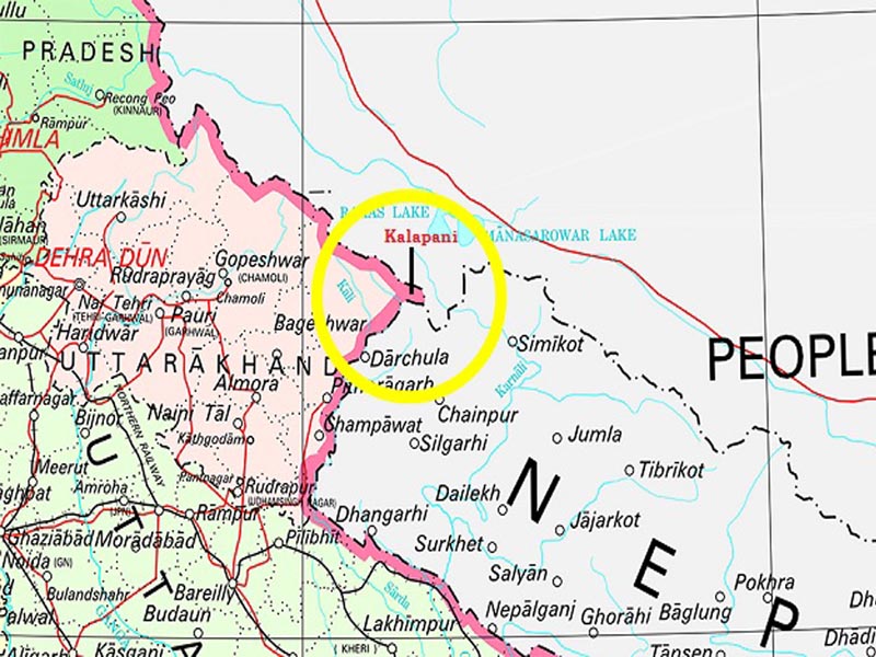
Why are India and Nepal fighting over Kalapani?
Nepal and India was revived in November 2019 when India published a revised political map showing the newly created Union Territories of Jammu and Kashmir and Ladakh. Both India and Nepal lay claim to Kalapani.
The map showed Kalapani as part of Pithoragarh district. Nepal protested immediately and drew attention to the lingering issue. On 8 May 2020, India inaugurated the Darchula-Lipulekh pass link road, cutting across the disputed Kalapani area which is used by Indian pilgrims to Kailash Mansarovar.
Nepal hit back by summoning the Indian Ambassador to Nepal to convey a formal protest.
The Kalapani territory is an area under Indian administration as part of Pithoragarh district in the Uttarakhand state, but is also claimed by Nepal since 1998.
All the land in Lipulekh, Kalapani and Nabhidhang on the Indo-Nepal border traditionally belongs to the residents of Garbiyang and Gunji villages of Dharchula sub-division of Pithoragarh district.
Garbiyang villagers say their ancestors cultivated the land in Kalapani before the Indo-China War in 1962.
Border trade between India and China through Lipulekh pass and the cultivation at Kalapani stopped after the war. Kalapani (37,000 hectares of land) has been controlled by India’s Indo-Tibetan Border Police since the Sino-Indian War with China in 1962.
River Kali was then recognised as the border line between Nepal and India.
What is the cause of the dispute?
The Kalapani region derives its name from the river Kali. Nepal’s claims to the region is based on this river as it became the marker of the boundary of the kingdom of Nepal following the Treaty of Sugauli signed between the Gurkha rulers of Kathmandu and the East India Company after the Gurkha War/Anglo-Nepal War (1814-16).
While Nepal’s claim of the territory east of Kali is based on the Limpiyadhura origin, India says the river actually takes the name Kali near Kalapani.
Now Nepal has published a revised official map incorporating the territory from the Limpiyadhura source of the Kali to Kalapani and Lipulekh pass in the northeast of the triangular region as its territory.
China is looking to create trouble for India by provoking its neighbors. Both China and Pakistan are planning to open another front by provoking Nepal against India.
 |
Ch. Naveen Kumar |


